POCKET PLAN AND THE PENNY POST
CARY, John.
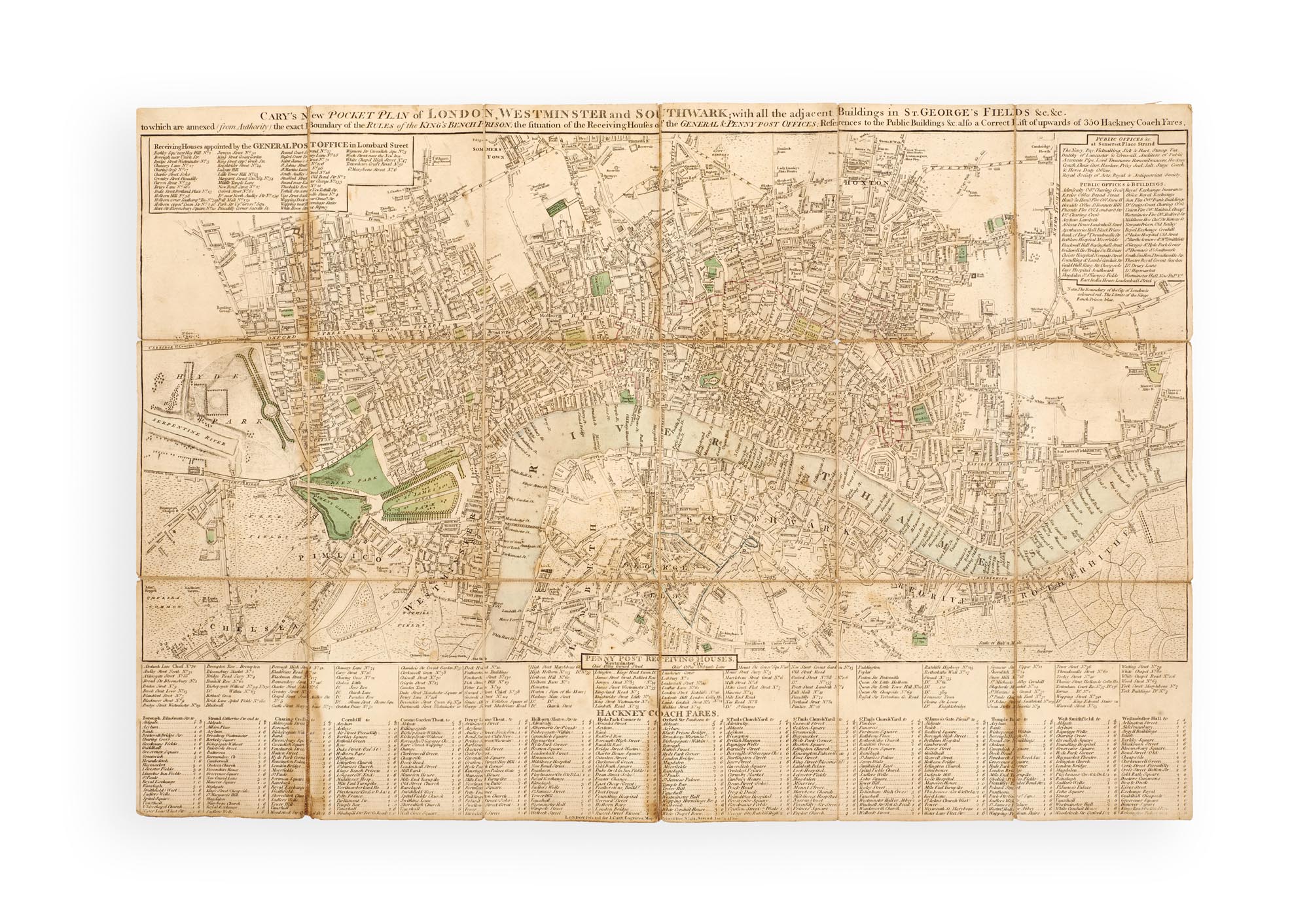
‘Cary’s New Pocket Plan of London, Westminster and Southwark; with all the adjacent Buildings in St. George’s Fields &c. &c. to which are annexed from Authority the exact Boundary of the Rules of the King’s Bench Prison; the Situation of the Receiving Houses of the General & Penny Post Offices; References to the Public Buildings &c. also a Correct List upwards of 350 Hackney Coach Fares’.
London, ‘Printed for J. Cary, Engraver, Map & Printseller, No 181, Strand,’ 1 January 1800.
Copper-engraved map (c. 411 x 610 mm), dissected in 18 sections and laid on linen; partially hand-coloured; a few light stains, but a very good copy; in the original slipcase with printed title and advertisement, very worn.
Added to your basket:
‘Cary’s New Pocket Plan of London, Westminster and Southwark; with all the adjacent Buildings in St. George’s Fields &c. &c. to which are annexed from Authority the exact Boundary of the Rules of the King’s Bench Prison; the Situation of the Receiving Houses of the General & Penny Post Offices; References to the Public Buildings &c. also a Correct List upwards of 350 Hackney Coach Fares’.
Cary’s folding pocket map of London, from Hyde Park and Chelsea in the West to Bethnal Green and Rotherhithe in the East, showing the development of London’s communications network.
John Cary (c. 1754–1835) first published his New Pocket Plan in 1794, the same year he was appointed as Surveyor of Roads by the General Post Office, and his Plan lists both the forty-seven General Post Office receiving houses and the 136 Penny Post receiving houses, as well as an extensive table of standardised fares for Hackney carriages, ranging from 1 s (e.g. Charing Cross to Bloomsbury Square) to 6/6 for journeys to Greenwich. The map remained in use well into the nineteenth century and was re-engraved several times, with changes here showing the development of London in 1800.
Perhaps the most influential map publisher of the late eighteenth and early nineteenth centuries, Cary’s work is regarded as ‘a considerable advance … in cartography as both a science and an art’ (Fordham, p. 439).
See Fordham, ‘The Work of John Cary’s and His Successors’ in The Geographical Journal 63, No. 5 (1924), pp. 438–440.